My last post was about the railroad tracks being built across East Main Street back in 1899. While doing research for that post I kept coming across all kinds of interesting stories related to the area between First Street and the tracks at Pigeon Creek. In this post I’ll discuss why this area was such a fascinating part of town, why it was the focus of so many stories in the Daily Republican and how a tiny seemingly insignificant building became the nerve center for the entire city.

A Beehive of Activity
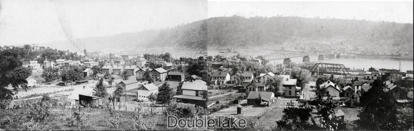
This area looks pretty nondescript today but in the early 1900s it was a hub for growing small businesses. While the largest factories located in other parts of town such as Liggets Spring and Axle, Coshocton Iron Co. or American Window Glass in New Eagle, a large number of our smaller businesses developed here.
In the map above it is possible to identify two churches, a factory, the Marble Works (where headstones were made for the Monongahela Cemetery and local burial grounds), Turners Hall (a german social club, dance hall and gymnasium), a bottling works, a general store, warehouses, a hotel, butcher shop, two slaughterhouses, a harness manufacturer, a carpet weaver, an icehouse, George Anton’s lamp factory, T.M. Boggs Foundry and Machine Shop, a tin shop, liveries, not to mention dwellings and a major coal mine, tipple and related businesses right across Pigeon Creek in Catsburg. It really was the heart of historic downtown Monongahela.
A Transportation Hub
In the map above you can see that this is where Pigeon Creek flows into the Monongahela River, the Ellsworth secondary & Pennsylvania Railroad merge here and you have a tangled mess of streetcar tracks, 4 bridges and 5 streets (Main St., First St., Chess St., Loup St., and Park Avenue.) all trying to coexist on the Pigeon Creek peninsula (known as “the island” to older generations).
The Tiny Mystery Building
I wrote about this area way back in 2008 before I had a Newspapers.com account. Back then there weren’t nearly as many historical resources available online as there are now but I did have access to Fowler bird’s-eye perspective map of Monongahela mentioned above (see the full map at the Library of Congress site). After hours of inspection 😜 I became obsessed with one tiny building at the junction of the Pennsylvania Railroad ( P.R.R.) and Elsworth Secondary railroads:

It looked too small to be a house and besides, who would want to live right there with all the noise, smoke and soot from all the trains passing by?
As the years went by, more and more resources became available on the web. I also would keep an eye out for Monongahela related ephemera on eBay. Then back in 2010, these two postcards popped up for sale:

The postcards possibly could help me identify the building but the eBay auction photo was so small that I couldn’t tell if it was even visible. Photos of this part of town are extremely rare though, so I purchased them thinking that I may be able to find the building if I could inspect the postcards in person.
When the postcards arrived, I was astonished. The images were razor sharp. I found out that these postcards are a special type known as “Real Photo Postcards”. This means that they were made with a special camera that produced an enormous 3 1/2″ x 5 1/2″ postcard sized negative which produced extremely detailed images. I didn’t have a magnifying glass, so I immediately scanned the postcards and uploaded them on my computer so I could zoom in and see every little detail. Lo-and-behold, I found the mystery building depicted in the drawing!

I still didn’t know what the building was, but it was nice to see an actual photo of it!
Signal Tower
A few years passed, and I discovered the Sanborn Fire Insurance Map collection on the Penn State Library website. There are several maps of Monongahela that give an extremely detailed look at how the city evolved over several decades from the 1880s to the 1920s. (There are even later Sanborn Maps, but they are still under copyright and aren’t in the public domain yet).
The first time this little building appeared on a Sanborn map was in the 1905 edition:
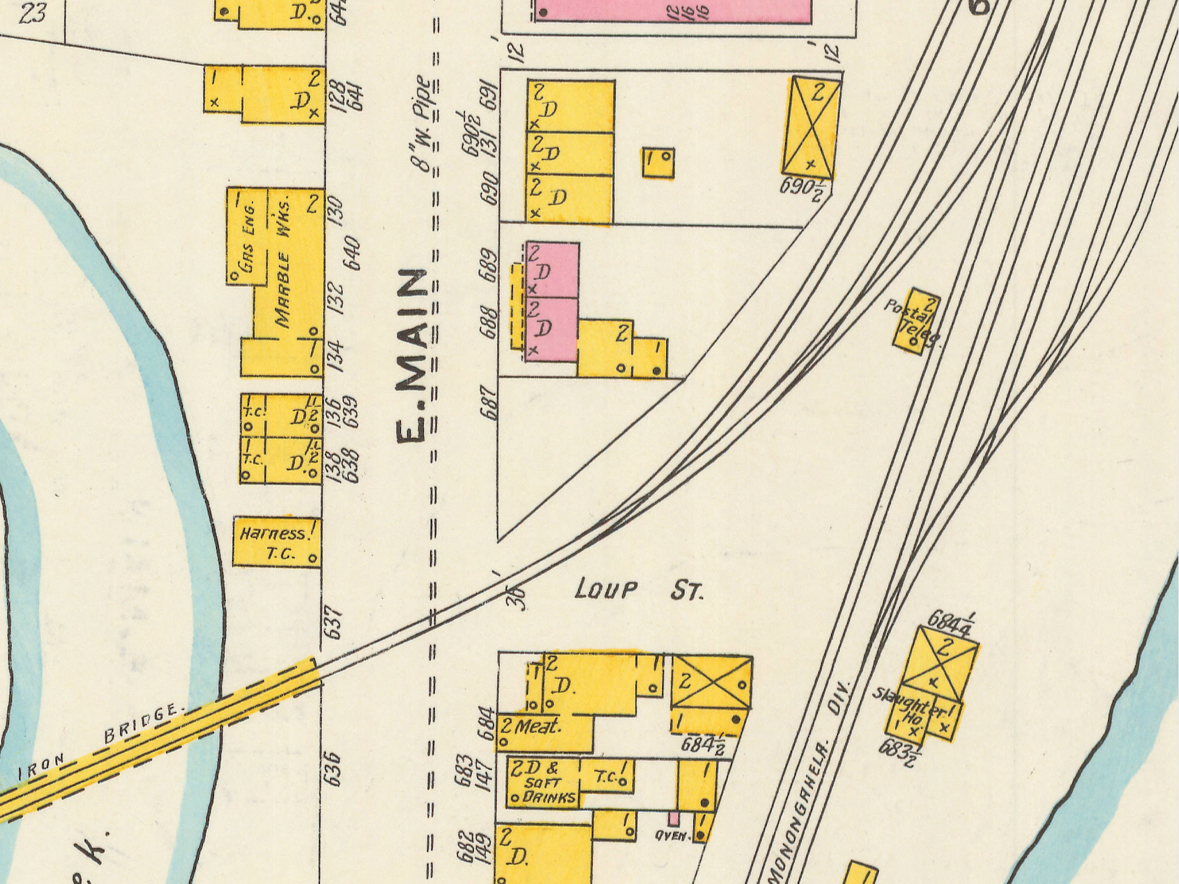
Sanborn maps can reveal a great deal of information. Zoom in further and you’ll find this:

The Sanborn map shows that the building was a wooden frame building (yellow means frame) which was two stories high (“2”) which had a slate or tin roof (hollow circle). This 1905 map also notes that this is a “Postal Teleg[raph]” building. Subsequent versions of Sanborn maps refer to this building as a railroad “signal tower”. Basically, a signal tower houses a human operator (aka signalman, switchman or leverman) and the control machinery the signalman used to operate the points and signals that allow trains to change direction at railroad “intersections” or more properly “junctions“.
The operator in the signal tower would control which direction an oncoming train would go. For example, a train traveling south on the Pennsylvania Railroad (now Norfolk Southern) would approach the tower and the operator in the tower would control (via a lever) whether the train would continue straight south along the river or whether it would bear right and travel up Pigeon Creek on Ellsworth Secondary. Signal towers were usually two-story buildings, so the tower operator would have a good vantage point and be able to observe everything going on in the area.
Once I knew that this was the Monongahela signal tower, it became much easier for me to search for other photographs of the building. Here is one you can find frequently on eBay:

So now we know that this building is a signal tower, but why is it described as a “Postal Teleg[raph] on the Sanborn map?
Postal Telegraph Cable Company
The telegraph enabled the railroad signal tower operator to communicate with his dispatcher (similar to an air traffic controller today) to ensure the safe and efficient flow of railroad traffic. According to this article from the Economic History Association: “The telegraph and the railroad were natural partners in commerce. The telegraph needed the right of way that the railroads provided and the railroads needed the telegraph to coordinate the arrival and departure of trains.” So it was natural fit for a telegraph company to have a presence at Monongahela’s P.R.R. railroad yard.
In 1902 Monongahela was served by two competing telegraph companies: the familiar Western Union Company and the Postal Telegraph – Cable Company At this time the P.R.R. was at war with Western Union (I’ll discuss that in a future post) but was on good terms with the Postal Telegraph – Cable Company. Many Daily Republican articles that mention Postal Telegraph – Cable Company also reference the P.R.R. in the same article which reflects their close working relationship.

.

It is hard to imagine, but instant communication with other people over long distances would still seem pretty magical to most people even in 1900. I imagine that a telegraph operator would hold the same prestige as an entry level computer operator today – both are “coding” after all.
24 x 7
As mentioned earlier, signal towers were usually two stories high with the tower operator working out of a second-floor room with windows all around. He could see oncoming traffic, be able to observe everything happening at the railroad yard and surrounding areas and be on the lookout for hazards that might cause a problem for an oncoming train such as a vehicle stuck at a crossing or a drunk passed out on the track. Also towers were manned 24×7, and the tower operator had access to the most modern communication systems. (I surmise that our Monongahela tower was equipped with both a telephone and a telegraph in 1900).

Our tower operator had an amazing view of Catsburg, the Monongahela River, Pigeon Creek, the main Monongahela bridge, the Ellsworth Secondary track and the whole railroad yard extending all the way down to 4th Street.

Every day the operator was watching for potential hazards, ready to report any suspicious activity to the police or the railroad dispatcher. Think of it as Neighborhood Watch on steroids. No wonder there are so many fascinating stories that can be found in the Daily Republican from this time: stories about teenagers arrested for swimming in the Monongahela river, train derailments, an eyewitness account of an enormous explosion on railroad street and an account of a man staggering across the Ellsworth Secondary bridge with a possibly fatal head-wound, suffering from amnesia with horribly mangled hands.
So look forward to future blog posts on Lost Monongahela about this fascinating part of town over the next few weeks!
Discover more from Lost Monongahela
Subscribe to get the latest posts sent to your email.

Very good blog?…! people are talking about this on our blog.🤑 😎
LikeLike
My mother Margaret “Peggy” Walters worked there until she retired in the 80’s.
LikeLike
Another Tower:
Does anyone know anything about the Glass Tower Market. It was, in the later 1940s I’m guessing, an open air fruit and produce/ice cream business a mile or so out of Monongahela along the 4th Street extension in Carroll Township. There were some structures, a restaurant and perhaps a gas station? Not sure why it was called ‘Glass Tower” it must have had some sort of illuminated landmark or another. Someone named William Hill was the owner according to a newspaper article. Anyone’s grandparents have any recollection of the place?
LikeLike